to the index page
Alaska was the last big family trip we took before my sister and I went off to college, the summer of 1998, the summer before senior year, and the last summer ever before I had a summer job. That year I bought a tent and a fancy new backpack and other camping equipment, and I was excited to be taking it all to Alaska for the ultimate wilderness test along with the camera I'd just gotten a year earlier.
The three-hour flight from Seattle to Fairbanks departed slightly late. We were stuck in the second to last row of an MD-80. This plane has two engines mounted directly to the fuselage at the rear of the plane and another in the vertical stabilizer. The left engine was 18 inches from my ear, and it was loud. It also blocked most of the view, but it turned out that this didn't matter because it was cloudy outside. There was no ocean in sight, but snow-covered mountains poked through breaks in the clouds from time to time. Through breaks in the clouds we saw the forested slopes and snow-covered mountains of Vancouver Island. Numerous smaller islands and peninsulas, all uninhabited, dotted the coastline. At 8:00 we were over Ketchikan AK, with clouds all around us. We soon moved above the clouds and passed over Juneau, and then moved inland. The clouds began to break up and lakes, rivers, and forested hills became visible below. There was no sign of habitation for a long time until a road and a few farm fields appeared among green hills outside Fairbanks. We descended past braided meltwater streams, glaciers winding through rugged mountains, and endless green forest, and landed at 5:35 local time.
They say it never gets too dark to read outside at this time of year. There are no Fourth of July fireworks and no warm, dusky midsummer nights. The sun was still high at 8:00 PM. I had no sense of direction since the sun made big circles and both rose and set to the North. It was 68 degrees, sunny and comfortable. We met friends at the airport who shuttled us to the car rental lot, where we picked up our suburban and piled our gear into it. The ten bags we brought made a small mountain in the parking lot but fit easily in the vehicle.
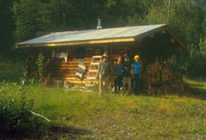
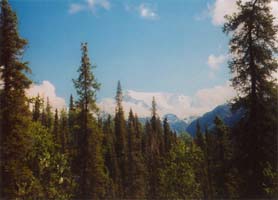
The trees in the area were rather thin and not very tall - spruce in the swampy lowlands, mixed with birch on the hills. We arrived at the house and moved into the beautiful log cabin they had made available for us. After dinner I took a look around, and was amazed by the striking differences from home. Pondering my travels of the previous year, I thought, "Hong Kong was a different place. This is a different world."
It never really got dark at night. Early in the morning the sky became lighter, but the sun didn't shine into the house until 6:00 AM. I slept well behind thick curtains closed against the light. Rested and with new energy, I began to explore the place. The forest was open and rather pleasant, with no insect activity. The cabin was a beautiful construction made from peeled spruce logs set on posts several feet high to accommodate ground shifts from the permafrost and to prevent heat from the cabin from softening the frost, which would cause the whole structure to tilt and sink. The cabin, the initial structure on the property, was built from on-site spruce. The house followed, also built on posts but towering two stories, it's foot-thick walls filled with insulation to keep out the cold. The cabin remained as a guesthouse and storage building, unattached and unheated in winter.
Having unpacked, we went into town to stock up on groceries and tour the Fairbanks University Museum, an impressive collection of Alaskan artifacts ranging from huge gold nuggets to an eight foot, nine inch brown bear from the coast. We also toured the University experimental farm and saw the test plantings of flowers and vegetables and pens of reindeer and traditional farm animals. That evening, we went into town to sit in on some folk music at the coffee house. They play on Friday nights - people drop by with their instruments and join in. Not a sheet of music was to be seen; all of it was memorized or improvised. It wasn't just the music, but the social atmosphere, that impressed me. People seemed to be much friendlier and happier there. Maybe it was from the isolation, or the long winter nights. "Alaska is quite a place. I'm not a tourist here; I'm at home" - at least in spirit.
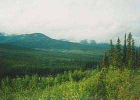
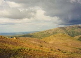
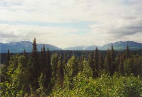
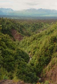
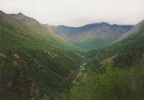
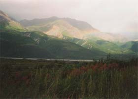
The sunny warm weather of the first two days was not continued into the third, and I awoke to a gray day with light rain at 6:00 AM. We packed up the suburban and headed out on the Steese Highway to Circle. We made a stop at the Alyeska Pipeline to inspect it up close. The giant steel tube rested on Teflon coated plates, free to move with expansion and contraction. Aluminum cooling radiators extended from the tops of some of the support towers. Moving onward, we soon left the pavement. We had the road and the spectacular view to ourselves. The sun peeked out from behind the clouds from time to time. Rough round-topped mountains and fast-moving rivers dominated the landscape, and spruce and aspen fill the low, sheltered areas. The Chatanika River ran beside the road in the valley. Areas near water had been dug up and dredged in the frenzied search for gold, and the scars were still visible. Some time later, we stopped atop the 3100-foot pass marking the divide between the Tenana and Yukon River watersheds. There were great views of the surrounding mountains, and the breeze kept some of the mosquitoes away. There were no trees on the hillsides or mountaintops, a sign of the harsh climate and the permafrost just below the surface. Ripples of soil that flowed down the hillsides as the soil was softened by the melting permafrost created wavy patterns on hillsides in the distance.
We stopped for lunch at another high pass and hiked a short distance to the rounded summit of a 3500-foot peak. The view was mostly hidden by clouds, which rolled in and began to scatter fat raindrops. Back on pavement by 1:30, we neared the town of Circle. Passing by the few buildings that were the town of Central, we drove over gravel once again, this time freshly graded. The sun had come out, the temperature had increased noticeably, and low hills and swampy lowlands had replaced the mountains.
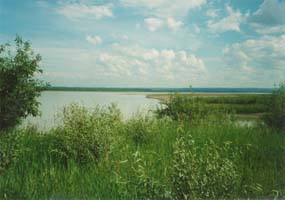
The handful of buildings, tiny post office, airstrip, and tourist center at Circle City, 162 miles from Fairbanks, were not very impressive. The road ended right at the river, and we pulled aside to a campsite. The Yukon River rushed past with surprising speed, ice cold and opaque with silt. This branch was about 500 feet wide. Since we were at the edge of the Yukon Flats, an area where the river spreads out and breaks into a maze of channels, the river we saw was only a part of the Yukon. The campsite we stayed at was in the open, grassy meadow bordering the river, squeezed in with the boat launch and the roadways - not a nice place, but good enough. It was breezy at least, so there were no mosquitoes.
I walked along the riverbank among the multitude of polished round rocks and driftwood fragments. Aspen and birch thickets lined the banks and I came across a beaver lodge with tracks covering the mud at the river's edge. Back at camp, it sprinkled lightly as we were cooking dinner, but this soon let up. The sun was still high at 10:00 PM, and I began to wonder how I was going to get any sleep in a tent. I dozed off and awoke at 1:00 AM to find the light intensity almost no different, though the sun was hidden by clouds or had dipped just below the horizon.
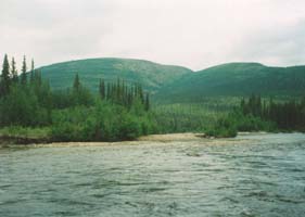
We packed up and headed out by 8:00 next the morning, eager to get out of Circle. Hares dashed across the road as we rounded every corner, and we occasionally saw ravens and red squirrels. The sky was a mix of clouds. Happily back in the mountains, we stopped at the Eagle Summit end of the 27-mile Pinnell Mountain Trail for a day hike. Along the way we saw golden plover, flocks of ptarmigan, and many songbirds, and we passed hundreds of tiny tundra wildflowers sneaking a bloom in between the seasons of ice and snow. There was a full spectrum of reds, yellows, blues, and purples, with colorful lichens adorning the rocks. The tundra was soft, spongy, and very wet. Elevations ranged from 3500 to 4500 feet, with the surrounding mountaintops reaching as high as 4900 feet. The views were great, but flies and mosquitoes followed us as we moved. After about three miles, we turned back. The weather alternated from blazing sun to cold rain and wind in cycles just a few minutes apart at times. We drove 22 miles to the other end of the trail, farther down the road, and hiked to a nearby mountain top that offered the same wind and sun but more spectacular views. Back on the road, we descended into the valley and paid $3 to camp at a deserted, unmanned campground in the heart of mosquito country. We chose a nice site on the bank of Cripple Creek, a fast-moving, ice-cold, clear-water creek 50-100 feet wide. The skies were friendly, and we cooked dinner without the wind and rain that had complicated the previous day's dinner operations.
It rained during the night, and we had to pack the tents wet again in the morning. The voracious mosquitoes never went to sleep, but our head nets worked well at keeping them away. We drove out at 9:30 in light rain. By 10:30 it began to rain hard, and there were no more scenic views. A moose crossed the road ahead of us as we neared Fairbanks. After stopping back at the cabin, we went to the Alaskaland historical theme park. We looked at old mine machinery, a steamboat, museums and gift shops, and two BLM and Parks Directory offices. I found that magnetic declination for compasses varies around the state from 17 to 30 degrees East, and that it had changed since many maps were printed - fortunately we could navigate by visual landmarks alone.
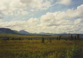
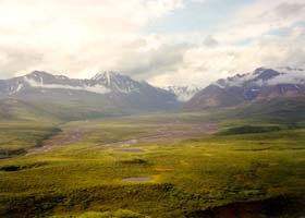
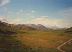
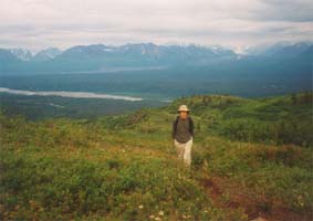
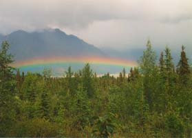
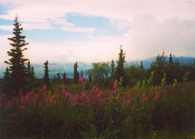
The sky was clear when I got up. We headed south at 7:30 and had gone less than a quarter mile when we came over a hilltop and saw the Alaska Range spread out before us, hidden by clouds for the past five days. Inspired by the distant snowy peaks looming on the horizon, we moved on. Filling up the gas tank, I was surprised to find that we had gotten 19 miles to the gallon. Gas was $1.23 per gallon, just a little more than the price at home. Two hours later we were driving through spruce and deciduous forest over low hills. A cow moose and calf crossed the road ahead of us. We passed brilliant pink fields of fireweed and gradually moved into more rugged country with snow patches in sheltered areas. We entered Denali National Part just after 10am and stopped at the visitor's center. The park is divided into zones, each of which is restricted to a set number of hikers to preserve the atmosphere of the park, and we had a tough time deciding where to go because the selection was limited. In the end we chose to go to the end of the road, in the Kantishna Hills, so that we could see the entire area. The area is quite beautiful, with rugged mountains hued in oranges and browns and covered with patches of snow. The wildflowers - yellow, purple, white, and red - lined the roadsides. Higher snowcapped peaks were visible in the distance, but we had not yet seen Denali. We camped near the visitor's center and planned an early start in the morning. The skies were clear, and we dried our gear and prepared for three days on the tundra. There was rain across the valley, but it stayed away and we were treated instead to a beautiful rainbow. It seemed that there were fare more rainbows here than at home - the low angle of the sun and the constant mixing of sun and rain frequently created them.
The following day we went to Denali. I was a bit worried that we would miss seeing the mountain in good weather, but the sunny skies held. We met a backpacker bus at 6:30 - a green school bus with the rear seats removed for packs and gear. The very friendly, talkative driver gave us an extensive running commentary, something usually reserved for the tour buses that cost more. Throughout the 85 mile, 6 hour trip on a winding gravel road, we heard ranger stories and learned about history, wildlife biology, geography, and geology of the areas we passed through.
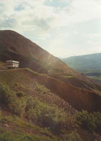
First we traveled over a paved two-lane road winding through spruce forest mixed with thickets of dwarf birch and willow. The gravel creek beds were dry, forming open pathways through the thick forest. We saw several caribou and moose as the trees began to thin. The road turned to dirt and we moved onto the tundra plateaus, brightly colored by a burst of summer wildflowers. As we climbed higher above the valley the views became increasingly spectacular. The narrow road cut into the loose gravel slope 200 feet above the flat riverbed below. Evidence of recent rockslides was uncomfortably abundant; no guardrails were present. At the inside corners the road was wide enough for two buses to pass each other, but on the outside corners there was usually only room for a bus and a half. Our bus driver sped along, seemingly without regard to this problem, and it was not until later that we figured out the rule: Incoming buses go, outgoing buses stop before rounding each hidden corner to watch the visible section ahead and wait to be sure the hidden section is clear.
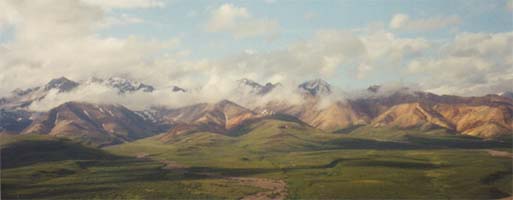
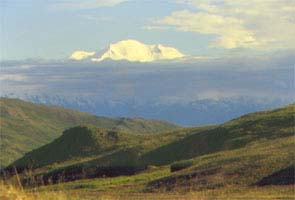
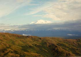
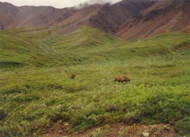
The mountains were colorful, rocky, and treeless. The higher ones in the distance had patches of snow. Our driver pointed out a Golden Eagle's nest, a mass of sticks on the vertical face of a cliff. Two adults and two mature chicks could just barely be seen with binoculars. Moving on, we eventually came to the first pass from which Denali could be seen. The cloud cover had broken up above us, but clouds partially covered the mountain. Nevertheless, the massive snow-covered range towered from the valley floor to 20,320 feet with spectacular splendor. As it stood alone among the hills, the sheer size of the mountain was apparent even though the summit was obscured. We passed two grizzly bears, an adult and a large cub, and a short time later observed two caribou moving across the tundra towards an immense male grizzly, both unaware of the other's presence. Approaching to within a hundred feet of the bear, the caribou suddenly turned and ran. The bear lifted his head, watched for a moment, and then went back to sleep.
Farther along we encountered many more caribou, sometimes waiting as they ran ahead of us along the road. A herd of about 15 Dall sheep, tiny white specks, climbed high on a ridge above us. The mountain began to clear as we moved into the grassy rolling hills opposite the range. The bright white of the snow contrasted sharply against the bright green lowlands with scattered spruce trees, wildflowers, and beaver ponds. The narrow dirt road had little traffic, partly because we were one of the first buses on the road that day so the few buses ahead of us had not turned back yet. Wonder Lake was actually a more of a pond, but it was the largest body of water in the area. By the time we arrived, clouds again obscured the mountain and the sun. We rode the bus a little farther to the extreme end of the road, where we departed and began hiking up an old mine road at an elevation of 1800 feet.
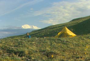
The road was wide enough for trucks, and we met two coming down. It climbed steadily, and mosquitoes swarmed after us. They were big mosquitoes - the largest yet - and head nets were a must. We saw a marmot, white-blonde colored - on a rocky outcropping. As we reached the top of the first ridge a thunderstorm hit, with a heavy downpour that turned into a steady rain. An hour later it let up and the fog quickly blew away, leaving the trail muddy and the bushes soaking wet. We chose a somewhat level tent site on an adjacent ridge at an elevation of 3400 feet. The rock-studded tundra was adorned with wildflowers, and a rainbow appeared out of the mist. The bugs remained until the sun came out and a light breeze moved in. We cooked dinner on the ridge, attempting to eat from inside partially furled nets ready to be pulled down whenever the breeze let up. A big bull caribou wandered in just above camp, and the clouds on the summit of Denali began to clear.
The mountain summit was a brilliant white in the sunshine, but gray clouds blotted out the middle section. I walked ten minutes to the rounded summit of the mountain, sidestepping around puddles and wildflowers. The great expanses dropped away and continued outward in every direction, and the view was spectacular. Everything seemed so big, yet our peak was only at 3900 feet. There was a small radio repeater station with antennas and solar panels at the mountaintop. The tundra was covered with the twisted, weathered roots of some kind of woody plant that had once covered the hills but was now gone. There was an eerie sense of timelessness and emptiness about the place; I looked out to the west at hundreds of square miles of nearly uninhabited land completely devoid of roads or any other human construction.
Thunder rumbled from time to time around us, but the sun still shone brightly at 9:30. We noticed the sky much more in his treeless place. "The park is as big as my home state of Massachusetts, and it's full of wildlife. Everything is big in Alaska, just like they say. The mosquitoes come out of the tundra a half an inch across the legs - twice the size as those back East. Temperatures swing from shorts weather to sweater weather in minutes, and it rains daily. My weather predicting skills were rendered useless on the first day, and I was left rather puzzled. It's a rough place, but it sure is beautiful."
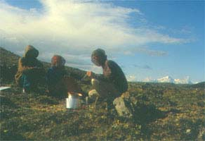
I woke up at 1:30 AM and looked outside to see clouds faintly illuminated by the sun. It was light enough to read. The cloud cover was broken and it remained dry. Light rain began around 4:00AM and continued through 11:00, and the hills remained foggy. My tent stayed dry because we were camped on a gravel ridge, but everything was damp. Some caribou wandered across a far ridge but there was no other wildlife - the ground squirrels were dry in their burrows. We had breakfast in the shelter of a rocky overhang a short distance away. As a precaution against grizzly confrontations, we cooked food a hundred yards from the tents and stored it a hundred yards from there, in a triangular formation, using the plastic containers provided by the park. Grizzlies do not frequent this area of the park but we took precautions anyway.
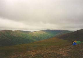
At midday the light rain continued to fall. Mist rose from the valleys and then suddenly disappeared into the air. We remained at camp, and I rested in my tent. At last, true vacation. "There's nothing to do but nothing to worry about in this peaceful land far from people and their problems." A curious ground squirrel was running around my tent, and I hoped that I wasn't camped over its burrow. I hadn't seen any holes. The rain stopped a while later, and some sun began to peek through the clouds. The fog cleared up but the cloud layer rested at 4000 feet, an oppressive ceiling hovering just above the mountaintops. The wind dried the tents and kept the bugs away, making it quite comfortable. We moved on to a nicer site a half-hour's walk away across a valley and higher up. We camped on a leeward ridge, a more sheltered site than the previous one. The ground under my tent was soft and lichen-covered, an improvement from the rocky surface of the last site.
There was no rain during the night, and it was cool - probably in the low 40s. It was another showery day. We left camp at 8:30 and hiked up into a brisk wind blowing the clouds over the mountains. We followed a mine road for about two hours and then cut across a saddle to the opposite ridge, stopping for lunch on a mountain peak at 3800 feet. There was some drizzle, but no heavy rain. There would have been a great view of Denali from the ridge had the clouds not obscured half the sky. We could see a hazy Wonder Lake below. I found some caribou tracks and fox prints, very well defined in the mud, but we saw no animals other than birds and ground squirrels. We camped at 2:30, mostly dry, on a windy ridge across the valley from where we had camped the night before. As I lay in my tent, on soft tundra once again, I pondered this lifestyle. "It's so much fun to live this way, freed from all the complexities of life in the outside world. If the rest of Alaska did not beckon, I would stay here. My tent is quite comfortable, especially on the soft tundra, and there is enough room for my pack and gear beside me. It is dry and warm in the tent, and I can relax because there is nothing else of importance that must be done."
The breeze kept the mosquitoes away after the first night, making it very pleasant. A little rain was quite tolerable given the improved conditions. All my new equipment worked great - the tent, sleeping pad, and pack - and the pack rain cover was especially nice. "The weather here is unpredictable. The wind comes from the southwest, but the clouds come in from the mountains to the southeast, stratified in different layers that sometimes move in different directions. The temperatures swing from 40 to 70 degrees in a few hours. The sun sets for only four hours, and it never gets very dark. I can't predict rain like I could at home, but we see it coming in the distance and pull out our rain gear. The rain comes in short waves and does not fall only from dark clouds. Looking out at the low cloud layer, I see ribbons of rain in the distance, each maybe a quarter mile across, falling from sections of cloud that looked no different from the rest. It's a wild place."
On the ground, there were many wildflowers, lichens, club mosses, and other little plants. I could identify some that I had seen at home, but there were so many. The tiny plants managed to shoot up a stalk four inches high topped with a giant yellow flower or a tower of pink petals, entirely out of proportion with the rest of the plant and the other minute tundra plant life. There were dark blue-green flower buds, little pink balls that grew out of a spiky green pincushion of tiny leaves, white bunchberry flowers only a quarter as large as the ones back home, blue forget-me-nots, and hundreds of other flowers in pink, yellow, red, and deep purple hues. The low places had small spruce trees, and 8-foot tall willow shrubs lined the stream banks in the valley. There were so many little lichens and mosses of many colors that the tundra was in places an 8-inch thick sponge, though the drainage on the slopes made some places dry enough to sit on. The wet areas seeped water at every step, and small potholes of water were scattered across the hillside. The whole place was a perfect breeding ground for mosquitoes. Rocky outcroppings hosted red, white, yellow, black, gray, and orange lichens.
I began to realize that the one thing missing in this peaceful place was good home cooking. I was getting better at using my stove, the trusty MSR Whisperlite, but ingredients beyond the freeze dried were nowhere to be found. I began to dream of pizza, fresh bread, and plates of spaghetti. It was all so far away. We planned to catch the early bus out of the park the next morning - a return to civilization.
Eager to move on, we got up at 6:00am so we would be at the bus stop in the valley at 8:30. Due to the rain, wind, and cold, we skipped the usual breakfast and opted to survive on trail mix and snickers bars instead. There was a trail that led into the valley, which was fortunate since the brush was very thick. The brush was also dripping wet, and we were also by the time we scrambled onto the road. After a 45-minute wait the bus arrived and we began the long trip back. Skies remained gray and dreary, with no views of the mountain. Still, it wouldn't be Alaska without rain. The trip back was a little different than the trip out - we had a friendly but less talkative driver and the bus gradually filled with, tired and hungry hikers excited at the prospect of returning to civilization. Nobody cared much about animals any more - "Caribou? Are they in the road? No... OK, let's go..." We did see two distant bears and three closer ones; two cubs came down to the bus and crossed the road behind us. These young northern bears are smaller than the coastal giants, only about three feet high at the shoulder. They look harmless, but we were advised that they are easily angered.
There was more bus traffic than we passed going in - all the morning buses were on their way into the park. We passed some herds of 20-30 caribou, a red fox, hawks, loons, and many "wild rocks." Instead of history our driver described in great detail the gigantic pizzas made at the Lynx Creek place at the end of the park road - with thick, juicy hunks of sausage, a soft crust piled high with layers of tomato sauce, mushrooms, and cheese... Having skipped breakfast and postponed lunch until our 2:00 arrival, this was really torture. We wondered if our driver was getting paid for this, but he denied it.
We arrived at the visitor's center and returned to our vehicle just as the sun was coming out. After a quick lunch, we headed on down the Parks Highway. Denali was still hidden by clouds. In Denali State Park we found a nice little campground, only $10 a night and very well maintained, with no other tent campers and a great view of the mountains. The mountain finally came out later in the day, in shadow since we were on the East side of the ridge and the sun was low to the West. The whole range was quite impressive but Denali was mostly hidden by nearer peaks.
Finally camping in dry weather, we built a fire to roast marshmallows and dry shoes. We cooked a big dinner in the sunshine. There were few biting insects. It was still bright and sunny at 10:15, and with everything dried out and sorted, I was ready to climb more mountains. I finally fell asleep, hoping to get up early to see the sunrise shine on the mountain.
In the morning I was disappointed to see overcast skies with a few sprinkles falling. We located a hiking trail into 4000-foot round-topped mountains a half-mile back up the road. The trail first wound through lush birch and spruce forest, and then came out into brush-covered hills. We continued up through dry tundra, not as spongy as it was in Kantishna but with the same flowers and lichens. Ascending through increasingly rocky terrain and boulder fields, we encountered some light rain as we neared the first summit. Mountains on all sides surrounded us, and there was a good view of the Eldridge glacier and its meltwater stream. I saw a flock of 15-20 ptarmigan among the rocks. There were many lichens, dark in color, but little vegetation.
By 1:00 it had become sunny and warm. Descending by a different route, we encountered a large patch of snow perfect for skiing in sneakers or hiking boots. Farther down the slope we observed two Dall sheep on the ridge, white with pointed horns, silhouetted against the sky. Back at the vehicle at 4:00, we drove on southward to look for a place to stay. In the town of Willow we showered and camped at a site beside Willow Creek. The water was teeming with three-foot long salmon, deep red in color, heading slowly upstream against the strong current to spawn. Some fishermen were trying to hook them, but the fish don't eat while spawning and are difficult to catch. We planned to restock our food supplies in Anchorage and then head East for a final hike before heading back north to Fairbanks. It was getting darker at night now than it did farther north - a combination of the diminishing daylight hours and the lower latitude.
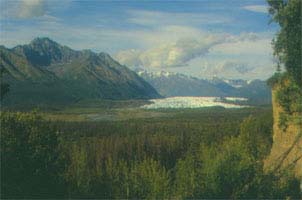
I awoke to a sunny morning, the first in a while. We got out early and decided to do our shopping and laundry in the town of Palmer to save the 40-mile drive to Anchorage and back. We refueled also, and I calculated that we had been getting 23 miles to the gallon, rather impressive for such a big vehicle. Here the highs were in the 60s, just like they were in Fairbanks. There were more houses and more stores, and much more traffic on the roads. The Talkeetna and Chugach mountains, with snowy peaks, rose to 7000 feet nearby, making the area quite picturesque. The spruce forest was thicker, mixed with willow, and the aspen trees were releasing their fuzzy seeds. This area is the agricultural center of the state, and vegetables can grow to immense sizes with the long daylight hours. We stopped for lunch beside a swift-running glacial stream, cold and silt-laden. We had hoped to hike in to the Mantanuska Glacier at it's source, but the landowners were charging $6.50 per person for entry, so we passed up the opportunity and viewed it from our campsite across the valley. There was no rain at all during the day, an unusual occurrence.
Another long day on the road took us through craggy mountain peaks to Valdez. We enjoyed some excellent views of the Wrangell Mountains and then moved away into forested hills as we climbed beside the Copper River. At about 2000 feet snow patches were abundant and trees scarce. The gray sky - typical of southern Alaska - shrouded the mountaintops. The Alaska pipeline ran along the road, leaping up over mountains and burrowing through hillsides. We had planned to walk a short distance to the base of the Worthington glacier along the way, but access was not permitted because the road was under construction. We descended into Valdez through Keystone Canyon, a narrow gorge wide enough in places only for the road, which competed for space with the river and sometimes ran directly over it. There were some nice waterfalls cascading over the rim above us; the entire area was very impressive.
Valdez was a large town with a very large oil port. There were parking lots filled with hundreds of RVs, awaiting passengers from cruise ships. We watched a film about the 1964 earthquake, which caused parts of the original town to settle and become submerged and created destructive tsunamis. Eager to escape from the rain, gray skies, and tourist-oriented RV city, we turned north again up the road we had just come down. Once through the mountains, we turned southeast onto the Edgerton Highway and drove into Wrangell-St. Elias Park. The highway eventually became the McCarthy road, which led into the old copper mining center. At our lunch stop we watched a team of five huskies pulling a man and his four-wheeler around a campground. The dogs were very obedient and did their job well. We camped at Liberty Falls State Recreation Area, which had a nice waterfall. It rained lightly, but we set up the tarp and began to pack for a 15-mile hike into the park to a public use cabin at the edge of a glacier. We cooked a huge pot of macaroni for dinner, attempting to use up some extra stores. The sky cleared up at 8:00, and we toasted some marshmallows. I puzzled over the range in gas prices around the state - we had paid $1.18 for gas in Palmer, but in Valdez it was selling for $1.48 to $1.52. They have to truck gasoline in over the mountains even though the oil pipeline ends there.
At 7:00 in the morning we left Liberty Falls campground, tents packed wet as usual and packs filled with supplies. We drove south on the Edgerton Highway to Chitina, where it became the McCarthy Road. An old rail bed, the road first passed through a very narrow slot cut into the rock for ore trains to pass through. The road was bumpy, worse than the Steese Highway, and narrower. We saw a few dozen hares along the way. For some reason they always ran to the far side of the road when we approached. We turned off onto a 2.5-mile long dirt trail, full of dips and puddles, and crossed a shallow stream to get to the trailhead. The trail followed an overgrown mining road, kept clear by light ATV traffic. Alders grew up thickly on both sides, rising 8-10 feet high and angling inward to form a tunnel several miles long. We passed some swampy areas, which were just damp enough to get my boots wet again, stopped for lunch at a small creek, and then continued up the gently sloping path. Along the way we scared up some squirrels, a few grouse, and more hares, and we passed a grizzly track in the mud. The forefoot print was as large as my hand with fingers spread apart.
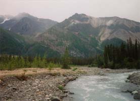
We arrived at Nugget creek at 2:30. The glacier had been visible higher up the slope for eight miles or so. The mountains were rugged and craggy, with snow covering the higher ones. At times, the lower reaches of Mount Blackburn, a particularly tall one - were visible, but clouds obscured most of it. There wasn't much rain, just a few sprinkles. Nugget creek was larger than the others we had crossed, and the water was milky blue with glacial silt. We forded it with rolled-up pants. The water was only knee-deep at its deepest point, but the current was very strong. Crossing rivers in Alaska is a risky business. The water temperature is in the 30s and the swift currents are dangerous even in the eight-foot wide channels of Nugget creek. If we got wet, hypothermia would be a real danger, and we were a full day's hike from the vehicle and many miles more from any kind of medical facility. We crossed without incident and found the cabin on the other side.
The name of Nugget Creek came from the copper mining activity, so my gold hunting was fruitless. The nugget from which the name came weighed several hundred pounds and was found upstream. I did manage to collect many colorful rocks from the gravel bars between the braided sections of the creek; only the finest were carried back out. The cabin was empty and very nice. Built in 1966 as a homestead, it was now owned by the Park and cared for by a local resident. It was 12 by 16 feet with a metal roof and a large oil drum stove, and cut firewood was stacked outside. It was well stocked with pots and pans, mattresses, odds and ends left by campers, and a logbook that mentioned, among other things, the visits of the nighttime porcupine. The mountain views were spectacular, even with the cloud cover, and a short distance from the cabin was the outhouse with the best view in the state.
We dried our tents and gear and built a fire to warm the place up. The mosquitoes were not bad and there was a light breeze. We had seen two people hiking out as we were coming in, but otherwise there was no sign of life. An airstrip was cleared along the stream bank and a very old green Dodge truck sat beside it. There were some old mine cabins up in the hills as well.
Overnight we discovered the powers of the woodstove. We put a few logs on and went to bed, only to awake a few hours later when the cabin had heated to about 95 degrees. We opened the door to let some cool air in, but the door was small and didn't help much. At least the heat dried out our gear. It was dark for a while at night, noticeably more than farther north. As the cabin cooled we fell asleep again, but we were gradually awakened by a gnawing sound from outside. The porcupine was at work on the cabin walls, indicating the origin of the tooth marks covering the corner joints and lower logs. We scared it away, but then the carpenter ants chewing inches from my head began to get annoying. Tired but otherwise comfortable, I noted: "I guess there's a price to pay to be warm and dry."
We awoke to sunshine but clouds soon obscured it. With day packs we set out to find the mine cabins and followed the trail upriver until it stopped. A second trail went up to the mines. There were some old cabins with collapsed roofs and a large ore-separating structure with blue-green ore scattered about in the tailings. It looked as if the crushed ore was hand-sorted or washed through somehow to separate it. We returned to the cabin for lunch, passing by a small privately owned cabin on the way down. It was quite nice, with a modern appearance and a spectacular view from its perch on an exposed ridge. On a distant slope we saw a small herd of sheep or goats.
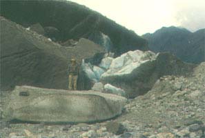
At 1:00 I set out with my father to explore the glacier. We walked down Nugget Creek, past the airstrip (which had been maintained and was fully functional despite the boulders and sharp rock fragments that littered the surface), and up along the gravel bank of the melt-water stream several hundred yards distant. We clambered over endless gravel fields, where rock was loosely piled into great mounds and treacherous pits filled with water abounded in the gullies. The rocks were of many colors and sizes, rounded and smooth. We passed some small grizzly tracks in the sand. There were many plants on the more stable surfaces. Each cluster of slender leaves sent up shoots six inches tall topped with fluffy blonde tufts. Soon we encountered ice, gray with layers of gritty sand and gravel and broken to form sharp cliffs. We eventually reached the riverbank and looked into the brown water rushing powerfully by. As we continued upstream we saw great mountains of fractured ice breaking up and crashing into the river as the water tunneled through hidden passageways. Pieces as large as houses and cars had broken off, and we watched numerous smaller pieces fall into the water. There was an almost constant stream of gravel and sand cascading over the edges of the ice cliffs, indicating the source of the silt in the water. Layers of ice and sand were visible, tilted at various angles, compressed, and distorted. We fished small pieces of blue ice out of the river and wondered how many hundreds of years ago they had fallen as snow in the mountains above. The whole place was unnervingly in motion, and we soon concluded that the distant white ice, higher on the glacier where melting was less severe, would be dangerous and difficult to reach.
We turned back through the woods to the cabin, crossing a freshly drained channel as we left the gravel bar. The river was like a living thing, constantly moving and changing location. Bear and fox tracks crossed the riverbed, indicating the recent presence of these animals we had not yet seen. Closer to the trees, the tufted flowers became very dense and formed a leafy mat. This was replaced by older gravel overgrown with moss several inches thick, lush lichens, and spruce trees. The rocks were weathered, and the lichens covered them with a uniform gray coating. Higher on the slope more plants grew, though bare rock remained and the path of the old riverbed could still be seen. Our path had taken us through the life cycle of the riverbed, starting with young gravel freshly released from the ice and ending with ancient lichen-covered deposits from a long-dry riverbed.
We were pleased to return to the warm cabin, for it would have been uncomfortable weather to camp in the tents. I rebuilt the outdoor fire circle in a keyhole shape for the benefit of future campers. With this shape, the cooking grate could be placed over the narrow end while keeping a larger fire going at the other end. Walking out to Nugget creek again, I found a small boulder weighing about thirty pounds lifted from it's resting place and overturned in the path, which we attributed to the work of a sizable grizzly. In this part of the state we had seen nothing else of this elusive animal but tracks. The rain stopped just before dinner and we saw a huge double rainbow hanging low over the valley. The colors were intense, but they soon vanished as heavier rain moved in around 5:30 and continued through the night.
The rain ended by dawn and we awoke after a quiet and restful night to clearing skies and bright sunshine. Just a thousand feet above us the mountaintops were dusted with fresh snow. The broken clouds soon moved out and we were treated to a beautiful view of Mount Blackburn, one of Alaska's higher peaks with a summit elevation of over 16,000 feet. The gigantic mass of snow-covered rock glistened in the sun and loomed surprisingly close. It dwarfed the lower peaks that had seemed high as we climbed through them the day before, ignorant of the size of the mountain above the clouds. We broke camp and forded Nugget Creek - a morning chill to get blood flowing in our feet. The six-hour hike out was very pleasant but tiring. There were no mosquitoes, and the sunshine even dried the alder tunnels so we didn't get as wet while passing through them.
We saw some grouse and rabbits, but no larger animals. There were more bear signs along the trail. After we had gone a short way down the trail the mountain cleared completely. It rose majestically above the surrounding country. We moved down the valley, and the magnificent view was soon hidden behind a mountain. The 14.5 miles passed slowly but the sun held, and by 2:40 we had reached the trailhead. We piled into the suburban and bounced back out along the road to the Richardson Highway, which we followed northward. We passed through gently rolling spruce forest, with the Wrangell Mountains spread out to the left and the peaks of the Alaska Range to the north. We stopped for the night at a campground on the Gulkana River. It was located in a spruce bog, with rock-hard gravel plots for sites and no fresh water. Unforgiving to tent stakes and uncomfortable to sleep on, it seemed to be primarily for RV camping. We carried two five-gallon jugs of water with us, and they came in handy now. The river was nice, about 100 feet wide and running clear. At dinner we prepared a feast of extra food and we turned in early to rest after our hike.
We got an early start driving north under cloudy skies. Rain began to fall as we entered the hills. We passed endless spruce forest and bogs and then moved into the higher peaks of the Alaska Range. We passed some glaciers and patches of snow, surrounded by high mountains. The upper reaches were hidden in the clouds. As we descended we drove out of the rain, and the skies cleared. We stopped at a salmon spawning stream and saw 12"-16" red salmon, about the same size as the gray-green ones we saw in Valdez but nowhere near the size of the ones in Willow Creek. We also saw a beautiful rainbow among the colorful mountains and spruce forest mottled with sunshine. It was a beautiful area.
Driving on, we moved into a region of low, forested mountains with the backdrop of the Alaska Range behind us. The pipeline ran parallel to the road and we saw stands of bright pink fireweed along the roadsides. There was very little traffic, and at one point the road ran straight as an arrow for eight miles. At 11:00 we stopped to take a tour of a pumping station on the pipeline. The facility was equipped with advanced leak detection and spill containment systems, and security was tight to keep people from disrupting them. The oil pumps were driven by huge gas turbines that pressurized oil from the initial 50 psi to 1100 psi. There was a complicated pressure regulation system to control line pressure as the oil flowed down from the mountains. Negative pressure was maintained in the buildings, instruments for detecting sparks, fire, and vapors were present in every room, and the entire place had a halon fire control system. The diesel pumps burn thousands of gallons of fuel each day. We learned that the oil supply is declining and the pipeline is seeing less use. It was built in 1977 for a 20-year term. The 48" pipe is insulated with 4" of fiberglass and protected with a galvanized metal jacket. Special animal crossings were placed where migration routes intersected with the pipeline, and the support towers often were outfitted with cooling fins and an ammonia coolant system to keep the permafrost solidly frozen. I found it interesting and reassuring that Alyeska Pipeline has set aside money for the complete removal of the pipeline and the restoration of the original environment.
We drove on under sunny skies and stopped for lunch at a state recreation area. There were some views of the Alaska Range peaks, but clouds to the south hid most of them. We reached Fairbanks at about 3:30, unloaded everything, and returned the car. We filled the 40 gallon tank with 39.035 gallons, showing that we had been running on empty into town, but at $1.20/gallon gas in Fairbanks was much more economical than the $1.58/gallon we passed farther back on the Richardson Highway. There is a refinery in North Pole, and the gas has to be trucked out from there at considerable expense. With the slower driving on the McCarthy Road and side trail, we only made 19 miles to the gallon. Our trip mileage was 1506 miles.
We spent the day resting up for the trip back, eager to return to the land of nighttime darkness with its fresh food and good home cooking. We drove about 20 minutes to a power line where the blueberries grew thickly. They were incredibly abundant; growing on 6-inch high bushes like bunches of grapes. Though much larger than the low bush berries of the East Coast, they were very acidic and not as sweet as the ones back home. The eight of us picked 25 or 30 quarts in about four hours. There were some afternoon showers, but by evening the sun had returned. The weather was as unpredictable as ever. Weather forecasts here are general and short-range, and they cover wide geographic areas. We turned in early after a wonderful salmon dinner, resting up for the long trip home.
We were up bright and early at 4:45 AM. It was just getting light; the daylight hours had shortened considerably in the last three weeks and were decreasing 5 or 6 minutes every day. We were driven to the airport and arrived at 5:40, but waited in line for half an hour before checking in and boarding the plane. We were seated in row 13 of an MD-80, well before the wing, so we expected a quiet flight with good views. The sun had not risen yet, and we looked out across Fairbanks in the twilight. Broken clouds above glowed in the morning sunlight, and the scene was very pretty. The seating proved to be very quiet, even more so than a Boeing jet because there were no engines on the wings. After taking off we followed the pipeline south over thin broken clouds, and soon the snow-covered peaks of the Alaska Range were visible. We flew over mountains and glaciers, the lowlands laced with fog and dotted with lakes and braided streams.
At about 6:40 we began to pass over the Wrangell Mountains. We could see the road we had followed a few days earlier, and were surprised to see the mountains, snowfields, and glaciers that had been hidden by clouds. Farther south we began to pass over the ragged coastline. Skies were clear, unusual for the coast. At 8:25 we passed over Ketchikan. It was low tide, and the coastline was bare. We continued to fly down the coastline, with many snowy mountains to the left. Hundreds of craggy peaks extended to the horizon, with blue ice fields in between the peaks. We gradually moved out of the mountains and landed in Seattle. The skies were cloudless but hazy, and the 84-degree temperature was a big change from the Alaskan highs in the 60s.
Flying out of Seattle, we quickly passed over the forested hills and moved into the dry brown expanse of farm fields and low hills. I changed my watch back to Eastern Time, discovering that it was already 5:30 PM. We were passing into Minnesota over green fields and the endless grid of roads. These gave way to rolling forested hills as we approached lake Michigan. We flew over cloudless skies until after passing Lake Erie, when I noticed that the land below was getting dimmer and that the sun was casting shadows on the clouds below. It suddenly struck me: It was getting dark! We landed in Philadelphia at 7:40 in darkness. The short 41-minute flight to Albany went by quickly, and we landed at 10:25 and recovered our bags. After three idle weeks our car battery was dead, and after jump-starting it we had a tense trip home hoping all the while that it would not stall. I was unaccustomed to the darkness and was a bit irritated that I couldn't see things.
We arrived home at 12:30AM, though it felt like it was four hours earlier. The lawn had grown tall, and temperatures were in the 70s. Insects chirped, and stars shone overhead. It was a completely different world from Alaska. "The daylight hours up north were convenient for traveling, but I think it would be difficult to live there. It's a wild place. Still, the mountains call, and I will have to return there someday to climb the snowy peaks, raft the raging rivers, and cycle the roads and trails of the backcountry."